(By Joe Mario Pedersen and Richard Tribou , Orlando Sentinel)
After nearly two months since the last named storm, Tropical Storm Danielle formed Thursday morning in the mid-Atlantic, and the first hurricane of 2022 could soon follow, according to the National Hurricane Center.
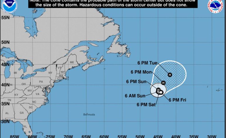
As of 5 p.m., Danielle was located about 950 miles west of the Azores with maximum sustained winds of 60 mph moving east at 2 mph. Deep in the mid-Atlantic, Danielle is no current threat to land and is forecast to “meander during the next few days.”
However, meteorologists are expecting Danielle to not only stick around but to also become the first hurricane of the season by this weekend, reaching a strength of Category 1 winds.
:quality(70)/cloudfront-us-east-1.images.arcpublishing.com/tronc/FLZXSG4WANFZFE56CTPOMIGOIQ.jpg)
Tropical-storm-force winds reach up to 45 miles from Danielle’s center.
Meteorologists are tracking two more weather systems with chances of becoming tropical depressions or storms in the next two to five days, according to the 8 p.m. Thursday outlook.
The first system with high chances is a broad and elongated area of low pressure located several hundred miles east of the Leeward Islands. The system is producing a large area of disorganized showers and thunderstorms although the system has lessened its coverage, said Lisa Bucci, an NHC specialist. The system has a50% chance of forming into a tropical depression or storm in the next two days and a 70% chance in the next five.
:quality(70)/cloudfront-us-east-1.images.arcpublishing.com/tronc/XOWEL2MROZBOZL4WYZ5SDPIOXE.jpg)
The system is forecast to move slowly west-northwestward, toward the adjacent waters of the northern Leeward Islands.
The system’s development could pose a problem for NASA’s plans to launch its Artemis I rocket Saturday. NASA officials noted the system’s potential path could be a threat to a Saturday launch after Artemis missed its Monday opportunity to blast off from Kennedy Space Center due to a fuel leak. Its next flight opportunities are during windows on Saturday and Monday.
https://platform.twitter.com/embed/Tweet.html?dnt=false&embedId=twitter-widget-0&features=eyJ0ZndfdGltZWxpbmVfbGlzdCI6eyJidWNrZXQiOlsibGlua3RyLmVlIiwidHIuZWUiXSwidmVyc2lvbiI6bnVsbH0sInRmd19ob3Jpem9uX3RpbWVsaW5lXzEyMDM0Ijp7ImJ1Y2tldCI6InRyZWF0bWVudCIsInZlcnNpb24iOm51bGx9LCJ0ZndfdHdlZXRfZWRpdF9iYWNrZW5kIjp7ImJ1Y2tldCI6Im9uIiwidmVyc2lvbiI6bnVsbH0sInRmd19yZWZzcmNfc2Vzc2lvbiI6eyJidWNrZXQiOiJvbiIsInZlcnNpb24iOm51bGx9LCJ0ZndfY2hpbl9waWxsc18xNDc0MSI6eyJidWNrZXQiOiJjb2xvcl9pY29ucyIsInZlcnNpb24iOm51bGx9LCJ0ZndfdHdlZXRfcmVzdWx0X21pZ3JhdGlvbl8xMzk3OSI6eyJidWNrZXQiOiJ0d2VldF9yZXN1bHQiLCJ2ZXJzaW9uIjpudWxsfSwidGZ3X3NlbnNpdGl2ZV9tZWRpYV9pbnRlcnN0aXRpYWxfMTM5NjMiOnsiYnVja2V0IjoiaW50ZXJzdGl0aWFsIiwidmVyc2lvbiI6bnVsbH0sInRmd19leHBlcmltZW50c19jb29raWVfZXhwaXJhdGlvbiI6eyJidWNrZXQiOjEyMDk2MDAsInZlcnNpb24iOm51bGx9LCJ0ZndfZHVwbGljYXRlX3NjcmliZXNfdG9fc2V0dGluZ3MiOnsiYnVja2V0Ijoib24iLCJ2ZXJzaW9uIjpudWxsfSwidGZ3X3R3ZWV0X2VkaXRfZnJvbnRlbmQiOnsiYnVja2V0Ijoib2ZmIiwidmVyc2lvbiI6bnVsbH19&frame=false&hideCard=false&hideThread=false&id=1565299181530386434&lang=en&origin=https%3A%2F%2Fwww.orlandosentinel.com%2Fweather%2Fhurricane%2Fos-ne-hurricane-season-orlando-florida-tropics-thursday-20220901-ebmjw5dit5f5rbm6xltqy7sdsa-story.html&sessionId=b0b6655b44ac281c615a4a9410abaeca6f11995d&siteScreenName=orlandosentinel&theme=light&widgetsVersion=1bfeb5c3714e8%3A1661975971032&width=550px
Additionally, the NHC is tracking a broad area of low-pressure northeast of the Cabo Verde islands. However, the system had its odds of development lower Thursday, and shower activity has diminished. The NHC gives it a 10% chance of formation in the next two to five days.
The system could become a short-lived tropical depression in a couple of days before heading into an unfavorable environment.
If any of the systems form into a named tropical storm, it would become Tropical Storm Earl. After that, the hurricane season’s names are Fiona and Gaston.
The 2022 hurricane season has had only three named storms and none since early July. If that sounds like hurricane season is moving slowly, it’s because it is. Typically, the fourth named storm of the year emerges by or before Aug. 15, according to the National Oceanic and Atmospheric Administration. The first hurricane is usually seen by Aug. 11.
But this season went the entire month of August without a named system. Despite the recent silence in the tropics, the NOAA still predicts an above-average year with 14 to 21 named storms as of an early August forecast. The hurricane season runs from June 1 to Nov. 30, with the traditional peak of hurricane season running from mid-August to mid-October.
The 2020 hurricane season set a record with 30 named systems, while 2021′s season was the third most active with 21 named systems. An average year calls for 14 named storms.


